


How do I find my zoning
Portland, OR
This is a guide to help those who wish to find the zoning information for a particular property in Portland by themselves.
It’s helpful to have a guide to make sure you are getting up-to-date, authoritative, and complete zoning information possible. That is what we are providing here.
Essentially, there are 3 ways to find the zoning information you need to start any design, construction, or land valuation work.
-
Hire a local professional (i.e., architect, contractor, land-use attorney)
-
Use UrbanForm
-
Do it yourself
There are valid reasons to do any of the above. Depending on how you value your time, your pre-existing familiarity with the codes, and other factors, one or another method may be best for any given set of circumstances.
There are many for whom doing it themselves may be their best option.
This guide is for those who wish to figure out how best to get the zoning information they need in Portland, Oregon. Please continue reading below.
Navigating the process
Generally, there are 5 steps to the task of acquiring zoning information for any city.
Use the links below to skip to any particular section, or the button below to go back to the very beginning
The first step is always understanding the jurisdictions.
When people say Portland, they generally mean the Portland Metro Area, which includes other incorporated cities such as Beaverton, Hillsboro, Gresham, and Vancouver, Washington. This Metro area is also called the Portland–Vancouver–Hillsboro, OR–WA MSA (a US Census-defined Metropolitan Statistical Area).
For any site, if it is within an incorporated city boundary (such as Portland, Beaverton, or Hillsboro), zoning authority rests with that incorporated city. Outside of incorporated city boundaries, authority is governed by the county zoning codes (such as Washington, Clackamas, or Multnomah counties).
What is confusing is that the address of a property does not correctly indicate which jurisdiction has authority. For instance, a property may have "Portland" in its address but actually be within City of Beaverton, City of Hillsboro, or unincorporated Washington County jurisdiction. It is important to find the incorporated city boundaries to determine the correct jurisdiction.

The Portland Metropolitan region includes many smaller cities such as Beaverton, Hillsboro, Gresham, and Vancouver (WA)
UrbanForm currently is available for properties within the City of Portland boundaries (outlined in dark black above), and the following information is only valid for those properties.
To find zoning information for properties in other cities in the Portland Metro area (such as Beaverton or Hillsboro), you will need to use the old-fashioned methods of hiring a professional or doing the research yourself. The 5 steps outlined in Navigating the Process are always valid, but the following particulars pertain only to the City of Portland.
The City of Portland’s zoning is currently managed by the Bureau of Planning and Sustainability (BPS), and its website can be found at: https://www.portland.gov/bps
Permitting and other development services are managed by the Bureau of Development Services (BDS), located at: https://www.portland.gov/bds
To find the zoning code, you need to go the official Portland City Charter, Codes, and Policies site, which has links related to the text of the code, as well as other useful links, here:
https://www.portland.gov/code/33
The city government websites seem to constantly be undergoing changes, and the links to the correct information move around, causing confusion since search links often point to legacy or outdated sites.
For the best results, and to make sure you are accessing the latest information, make sure you are looking at the most recent version of Title 33 from Portland.gov
Navigating the process
Generally, there are 5 steps to the task of acquiring zoning information for any city.
Use the links below to skip to any particular section, or the button below to go back to the very beginning
Get an overview of the zoning code.
To get oriented with Portland’s zoning code, there are a couple of decent places to start.
The first is the BDS website, which has an Overview of the Zoning Code page:
https://www.portland.gov/bds/zoning-land-use/zoning-code-overview

A screenshot of the Portland.gov website as of Jan 1, 2023
This page briefly discusses the different types of zoning districts, the hierarchy of the regulations, and what to do when there are conflicts in the regulations. The key thing to know is that there are essentially 3 overlapping classes of zoning districts, listed in the order of their precedence:
-
Plan districts
-
Overlay zones
-
Base zones / additional use / development regulations
The BDS Overview webpage is a decent introduction to navigating the zoning code. But it is brief and therefore incomplete. A better guide exists within the zoning code text itself, which we will discuss further below.

Plan Districts

Overlay zones

Plan Districts + Overlay zones overlaid
As stated on the Overview of the Zoning web page, “Plan district regulations supersede regulations in overlay zones, base zones and land division series of chapters. Overlay zone regulations supersede regulations in base zones and land division series of chapters. Plan districts and overlay zones regulations also supersede conflicting regulations for a specific use or development stated in the additional use and development regulations series of chapters.”
45,324 lots out of 196,734 are affected by Plan Districts (above top left).
77,640 lots are affected by Overlay zones (above top right).
In total, 96,931 lots are affected by a Plan District, an Overlay zone, or both (above bottom). That’s 49.3%, or almost exactly half of the lots in Portland.
This is probably the most important thing to note, and most likely the reason for the vast majority of erroneous zoning interpretations. Half of the properties in Portland have their base zoning regulations modified by one or more overriding overlay zones or plan districts.
And that doesn't even mentioned the Pattern Areas, a crucial location based distinction which modifies the zoning regulations for every single lot in Portland.

"How to Use This Document" from Title 33's Introduction
The second good introduction to Portland’s zoning code is within the code text of Title 33 itself. This is more complete and detailed than the "Overview of the Zoning Code" webpage discussed above.
In the 33.10s section of the Portland City Charter Title 33, there is a “How to Use This Document [Title 33]” section.
This is a good place to start to understand the overall structure and hierarchy of Portland’s zoning.
Within this text is a section called “Determining the Zoning Regulations for a Specific Site.” See below.
Determining the zoning regulations for a specific site:
-
“Find the site on the Official Zoning Maps”
-
Find the “base zone that is applied to the site.”
-
Check “if the site is subject to any overlay zones or plan districts, and if the site contains a historical landmark or recreational trail”
-
Then “look up all the corresponding regulations. . . Start with the base zones (the 100 series of chapters).”
-
Determine “if certain reviews are necessary, such as conditional use review. In these cases look up the appropriate chapter.”
-
“Some uses and types of development have specific regulations stated in the 200 series of chapters. Although such instances are referenced in the base zones, it is a good idea to check over the 200 series to confirm if any of the chapters apply to your situation.”
-
“Next, look up any overlay zones or plan districts that may apply to your site. These are listed in the 400 and 500 series of chapters.”
-
“Finally, if the Official Zoning Maps indicate that the site has a historic landmark or recreational trail designation, look up those chapters for the corresponding regulations.”
-
“Chapters 33.910, Definitions and 33.930, Measurements may be helpful in understanding how to apply the regulations to a specific site.”
Extracted from the Portland's zoning code Title 33 "How to Use This Document" section
In the above section, nine (9) discrete steps are called out to make sure that complete zoning information for a site is gathered.
This is a handy, complete, step-by-step procedure for how to find accurate zoning information for a property in the City of Portland, Oregon, direct from the governing document itself.
If you're exhausted just by reading those steps, that's understandable. I don't think anybody is happy that this is what is required. Those 9 steps above are the process that's manually undertaken every time someone needs to know what can be built on a property. This process is what UrbanForm has automated and made available instantly.
If you still need to proceed yourself, we'll discuss those nine (9) steps next.
The first step is finding the maps, and that’s what we’ll discuss next.
Navigating the process
Generally, there are 5 steps to the task of acquiring zoning information for any city.
Use the links below to skip to any particular section, or the button below to go back to the very beginning
Once we’ve established the jurisdiction with authority, found the correct sources of information, and gotten a brief overview of the structure of the zoning, we need to start the work of getting the information. There are two things that compose zoning: maps and text. The next step is finding the maps.
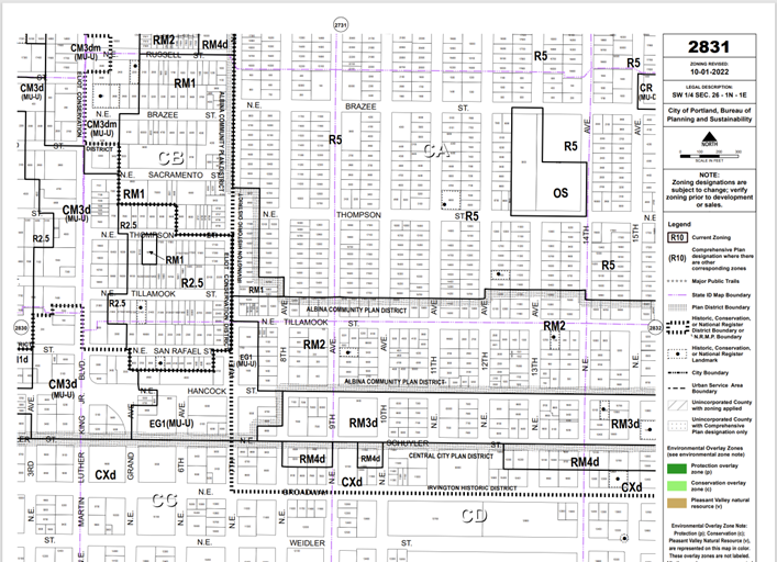
An official Zoning Quarter Section Map
For Portland, there are three main ways to get the maps you need:
-
The Zoning Quarter Section Maps. These are the official zoning maps, essentially PDFs that you can view and download (above)
-
PortlandMaps, a website provided by the City of Portland
-
The Portland Zoning App, a website provided by the City of Portland
The Zoning Quarter Section Maps are the official and authoritative map but are static, difficult to access, hard to search for by address, and confusing to read.
Essentially, you will have to find the address for your site on another map (such as Google Maps), then find the right Quarter Section Map, and then compare the two maps to find out where on the Quarter Section Map is the property you are interested in, and then study it closely to extract the base zone designation as well as any other appropriate district or overlay.
Practically, the Zoning Quarter Section Maps have been superseded in utility by the other two options, PortlandMaps and the Portland Zoning App.
We'll discuss the Portland Zoning App next.

A screenshot of the Portland Zoning App website as of Jan 1, 2023
The Portland Zoning App (https://www.portlandmaps.com/bps/zoning/) is an interactive web app where you can zoom in and out, click on properties, and search by address to find zoning summaries and guidelines for the zoning districts.
This is a good site to familiarize yourself with the purpose and intent of the zoning designations, as well as find links to specific information. It helpfully lists the Overlays and Plan Districts that apply, as well as provides links to the official Title 33 code to find more detailed information.
It also has links to the official Zoning Quarter Section maps as well as more detailed site information available on PortlandMaps (see following page).
The Portland Zoning App is a product of City of Portland Bureau of Planning and Sustainability (BPS) with design and development provided by BPS's Technical Services team.

A screenshot of the Portland Zoning App website as of Jan 1, 2023, with certain sections highlighted
But the Portland Zoning App (https://www.portlandmaps.com/bps/zoning/) currently doesn’t provide several crucial pieces of information required for any architect or builder looking to assess design or development options.
To start, the Zoning App doesn’t provide good site information, such as the size of the lot, or facts about any existing structures that may be present. This information is often required for any formulas that are then used to calculate allowable floor areas, lot coverage limits, or setbacks.
And for detailed, site-specific information, it usually presents numeric ranges that are too broad to be of any use to someone looking to make design or development decisions (see above). To determine what is the precise zoning rule for a particular site, you will need to click the links to Title 33 and do the research yourself to see what applies.
At the very least, the Portland Zoning App needs to be used in conjunction with PortlandMaps and an separate thorough review of the Title 33 code in order to provide complete information. We'll discuss PortlandMaps next.

A screenshot of the PortlandMaps website as of Jan 1, 2023
PortlandMaps (https://www.portlandmaps.com/) is probably the most useful government website, providing detailed information, including zoning, but also civic information such as safety, schools, and transportation.
Since there is a lot of information, it takes some get acquainted with where information is presented and how to navigate the site. But once you are familiar with it, it is the easiest site to use to get detailed site information.
In PortlandMaps, the zoning district designation as well as overlays are displayed. Also available are the site data and assessor information. It’s probably the single most useful site from the city, even more so than the Zoning App, since the Zoning App provides information that is too general to be useful and lacks some crucial site information.
PortlandMaps was built and is maintained by Corporate GIS (CGIS), and the Bureau of Technology Services (BTS) at The City of Portland.

A screenshot of the PortlandMaps website as of Jan 1, 2023
However, PortlandMaps (https://www.portlandmaps.com/) still doesn’t provide crucial site-specific information necessary to make design and development information.
To determine exactly what zoning and development standards apply to a specific site, such as the height limit, FAR, and coverage limits, it still requires you to find the correct Title 33 code sections on your own. In fact, clicking on links from PortlandMaps will send you to the Portland Zoning App. From there, you need to click on the links to the Title 33 text.
Experienced professionals can often become quite adept at using PortlandMaps in combination with their familiarity with the Title 33 zoning chapters (which are available as PDFs) to gather the requisite information themselves. But this requires knowing exactly where to get the right information, clicking on the correct links, reading, deciphering, copying and pasting, and doing the manual calculations and drafting to gather the relevant information for each site.
We'll discuss navigating through the text of the zoning code next.
Navigating the process
Generally, there are 5 steps to the task of acquiring zoning information for any city.
Use the links below to skip to any particular section, or the button below to go back to the very beginning
Read through the text to pull out the relevant zoning information.
Once you've determined the correct jurisdiction, the right sources of information, gotten a general understanding of the structure of the zoning, found the maps, and identified all relevant base zone code designations as well as overlays, plan districts, and other location information, it is now necessary to dive into the zoning code text.

Format of the zoning code:
Title 33 Chapters
-
10s Introduction
-
100s Base Zones
-
200s Additional Use and Development Regulations
-
400s Overlay Zones
-
500s Plan Districts
-
600s Land Divisions and Planned Developments
-
700s Administration and Procedures
-
800s Land Use Reviews
-
900s General Terms
Portland's zoning code text is called Title 33, and PDFs of the comprising chapters are hosted on the Portland.gov website: https://www.portland.gov/code/33
Within each of the chapter groupings above are the individual chapters (for instance, within the “100s Base Zones” are Chapter 100, 110, 120, 130, 140, and 150).
For example, 33.110.050.B. refers to Subsection B. of Section 050, of Chapter 110, of Title 33. The names "Title" and "Chapter" are used if the reference is to an entire Title or Chapter.
It's crucial to document exactly where information is found, because during subsequent reviews and or discussions about zoning specifics, it is invariably necessary to refer back to specific text locations. Documenting and verifying the source is a fundamental part of the process of establishing the zoning parameters, and it is something that UrbanForm has also automated.
Base zones:
-
Single Dwelling Zones (RF, R20, R10, R7, R5, R2.5)
-
Multi-Dwelling Zones- (RM1, RM2, RM3, RM4, RX, RMP)
-
Commercial / Mixed Use Zones - (CR, CM1, CM2, CM3, CE, and CX)
-
Employment and Industrial Zones - (EG1, EG2, EX, IG1, IG2, and IH)
-
Campus Institutional Zones - (IR, CI1, CI2)
-
Other (OS)
28 base zones total
All properties within the City of Portland have a base zone.
It is helpful to know that there are 28 different base zone designations grouped in 6 different categories (see above).
To know which chapter of Title 33 to look within, you must first know to which zone category the base zone designation belongs, as the Base Zone chapters are organized by category.

Overlay zones
Overlay zones:
-
b – Buffer zone. See Chapter 33.410
-
d – Design overlay zone. See Chapter 33.420 and Design Review
-
c or p – Environmental zone. See Chapter 33.430, Environmental Review and Environmental Plan Check
-
f – Future urban zone. See Chapter 33.435
-
g* or e – River overlay zones. See Chapter 33.475
-
g, i, n, q, or r – Greenway zones. See Chapter 33.440 and Greenway Review
-
h – Aircraft landing zone. See Chapter 33.400
-
k – Prime industrial zones. See Chapter 33.471
-
not shown on maps – historic resource protection overlay zone. See Chapter 33.445 and Historic Reviews
-
m – Centers main street overlay zone. See Chapter 33.415
-
s – Scenic resource zone. See Chapter 33.480
-
v – Pleasant valley natural resources overlay zone. See Chapter 33.564
-
x – Portland International Airport noise impact zone. See Chapter 33.470
-
z – Constrained sites overlay zone
20 overlay zones total
Per Portland.gov:
“Overlay zones consist of regulations that address specific subjects in particular areas in the City. Overlay zone regulations are in addition to regulations in the base zone and modify the regulations of the base zone.”

Plan Districts
Plan Districts:
-
Albina Community Plan District. See Chapter 33.505.
-
Cascade Station/Portland International Center Plan District. See Chapter 33.508.
-
Central City Plan District. See Chapter 33.510.
-
Columbia South Shore Plan District. See Chapter 33.515.
-
Division Plan District. See Chapter 33.520.
-
East Corridor Plan District. See Chapter 33.521.
-
Gateway Plan District. See Chapter 33.526.
-
Glendoveer Plan District. See Chapter 33.530.
-
Guild’s Lake Industrial Sanctuary Plan District. See Chapter 33.531.
-
Hayden Island Plan District. See Chapter 33.532.
-
Healy Heights Plan District. See Chapter 33.533.
-
Hillsdale Plan District. See Chapter 33.534.
-
Hollywood Plan District. See Chapter 33.536.
-
Johnson Creek Basin Plan District. See Chapter 33.537.
-
Kenton Plan District. See Chapter 33.538.
-
Laurelhurst-Eastmoreland Plan District. See Chapter 33.540.
-
Lombard Street Plan District. See Chapter 33.545.
-
Macadam Plan District. See Chapter 33.550.
-
Marquam Hill Plan District. See Chapter 33.555.
-
North Cully Plan District. See Chapter 33.560.
-
North Interstate Plan District. Chapter 33.561.
-
Northwest Plan District. See Chapter 33.562.
-
Northwest Hills Plan District. See Chapter 33.563.
-
Pleasant Valley Plan District. See Chapter 33.564.
-
Portland International Airport Plan District. See Chapter 33.565.
-
Portland International Raceway Plan District. See Chapter 33.566.
-
Powell Boulevard Plan District. See Chapter 33.567.
-
Rocky Butte Plan District. See Chapter 33.570.
-
Sandy Boulevard Plan District. See Chapter 33.575.
-
South Auditorium Plan District. See Chapter 33.580.
-
St. Johns Plan District. See Chapter 33.583.
-
Swan Island Plan District. See Chapter 33.585
32 Plan Districts total
Per Portland.gov:
“Plan district regulations are applied in conjunction with a base zone. The plan district provisions may modify any portion of the regulations of the base zone, overlay zone or other regulations of the zoning code. The regulations of a plan district may also apply additional requirements or allow exceptions to general regulations.
Where there is a conflict between the plan district regulations and the base zone, overlay zone or other regulations of the zoning code, the plan district regulations control. See Chapter 33.500.”

Plan Districts + Overlay zones overlaid. The Plan Districts are in red, the Overlay Zones are in pale yellow, and where both an Overlay and Plan District apply is shown in orange
28 base zones
+
20 overlay zones
+
32 plan districts
=
80 zones
Don’t forget the hierarchy of the regulations, per Portland.gov:
“In general, an area with base zoning, overlay zoning or an area in a plan district is subject to all of the regulations of each.
When the regulations conflict, unless specifically indicated otherwise, the following rules apply:
-
Plan district regulations supercede regulations in overlay zones, base zones and land division series of chapters.
-
Overlay zone regulations supercede regulations in base zones and land division series of chapters
-
Plan districts and overlay zones regulations also supercede conflicting regulations for a specific use or development stated in the additional use and development regulations series of chapters.
-
The regulations in the additional use and development regulations series of chapters supercede regulations in the land division series of chapters
-
When regulations at the same level conflict, those that are more specific to the situation apply.”
This is generally how reading through Title 33 should be structured to make sure you don't miss any crucial zoning information that could affect your property:
-
first, the base zone chapters (the 100s chapters),
-
then the overlays (if any are applicable) (the 400s chapters),
-
then the plan districts (if any are applicable) (the 500s chapters), and
-
then the additional use and development regulations chapters (the 200s chapters).
-
Finally, the 900s chapters include specifics on how measurements and formulas (including things like rounding numbers) are calculated, so it's important to review those chapters.
While doing so, given the vast amount of information needed, and their locations scattered throughout many chapters and pages, it's crucial that you document what information you found and where. This is what we'll discuss next.
Navigating the process
Generally, there are 5 steps to the task of acquiring zoning information for any city.
Use the links below to skip to any particular section, or the button below to go back to the very beginning
Document clearly the information and sources you've researched.
Once you've determined the correct jurisdiction, the right sources of information, gotten a general understanding of the structure of the zoning, found the maps, and identified all relevant base zone code designations as well as overlays, plan districts, and other location information, and read through the zoning code to identify the relevant parts, you now need to make sure you can reference this information easily.
Zoning information needs to be studied, communicated to others, verified it with others, and used to justify your work. So the documentation of the zoning information you've researched is extremely important.
This no small task, and the one that will save you the most time if you do it properly.
Professionals often develop their own internal spreadsheets and documents to guide them through this process for each jurisdiction. This should be a part of their internal operations that help them create efficient professional processes.
But the basic task is the same in any such process:
-
identify the relevant information,
-
write it down somewhere, and
-
note the sources.
Everything in this guide up until this point was just about accomplishing task number 1 above; each person will have their own preferred way of doing numbers 2 and 3.
For Portland, it's helpful to keep in mind the format structure of Title 33, as that is how the source location should be noted for easy reference.
For example, 33.110.050.B. refers to Subsection B. of Section 050, of Chapter 110, of Title 33. The names "Title" and "Chapter" are used if the reference is to an entire Title or Chapter.
Once this has been accomplished, then you've successfully found the zoning information for a single property. Congratulations!
Based on surveys with UrbanForm customers, and from our own professional experience, we've found that this process takes between 3-4 hours for someone with decades of experience in that particular jurisdiction, to 2-3 weeks for someone who is doing it for the first time. For an average professional, the median seems to be about 12 hours allotted to the process of acquiring zoning information.
It's worth noting at this point that this entire process is exactly what UrbanForm has automated. In under 20 seconds, the entire process detailed above can be completed by using UrbanForm.
We understand that there are times when the old-fashioned, manual way of acquiring zoning information may be the most suitable. UrbanForm was developed as an alternative.
Also, we understand that the sources are constantly evolving. One of UrbanForm's primary values is continual improvement, so if there is anything that anyone sees which could be improved, we'd love to hear from you. Leave a comment or reach out to us at our contact information below.
